Mt. Cain Snow Scene Gallery - Lunch With a Million Dollar View.
When you reach the top of the upper T-bar you can see a mountain scene in every direction. Directly up the hill you can see the tip of Mt. Cain towering above the hiking train forged by die-hard out-of-bounds skiers and borders (picture 1 in gallery below). When you turn around for the first time your eyes are treated to a snow scene that takes your breath away.
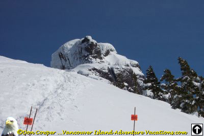
1. Your first sight after seeing the T-bar around the top end fly-wheel, is the peak of Mt. Cain. In the foreground is the hiking route to upper out-of-bounds slopes.
2. When you turn around this is the snow scene on display back down the upper T-Bar.
3. Here I zoomed in on the mountains ranges in the distance.
4. Turning to our right we see some of Mt. Cain's finest ski patrollers. The road behind them is the easiest way down from the upper T-bar.
5. It was about 12:30 when we reached the top of the upper T-bar. You can see it here in the background. We decided to sit down for an out-door lunch. A million dollar view!
Below the main picture (left to right)
6. This scene is taken looking off to the right. Here we can see several distant mountain ranges. We are looking north-north-west in this picture.
7. This snow scene shows areas in white where blocks of trees have been harvested in the recent past. Most of these areas have been replanted. We can see the end of one of the Klaklakama Lakes in the center left of this picture.
8. Here Mt. Able in the foreground draws your eye as it races towards you. In the center back we can see Maquilla Peak in the Sutton Range.
9. Seemingly close enough to touch, Mt. Able glistens under a cover of new pristine white snow.
10. The out of bounds marker (yellow sign) beckons to the Mt. Cain - Mt. Able bowl and yet another out-of-bounds snow scene.
Tremendous Mountain Views
Picture #2 shows the view back down the T-bar towards the north-west.
I used my three times optical zoom to take a close up of the mountain range in the distance in picture #3.
If you turn to the right from here you see the road leading across the top of the ski area.
Scene #4 shows the road and two of Mt. Cain's finest ski patrollers. These folks give their time and expertise to help keep regulars and visitors alike save on Mt. Cain.
This road leads to the easiest way down from the top T-Bar.
We turned to the right after taking some pictures and headed towards Mt. Able. We choose the spot shown in photo #5 to sit down for lunch.
On a clear day you can see a long way and take in several mountain ranges. Mt. Able is close at hand. A million dollar view for a skiing lunch!
Shots 6-10 were taken from right to left as we sat for lunch. The composite of these shots is featured on my
Mt. Cain Trail Map page.
Another Snow Scene Gallery | Return To the Mt. Cain Trail Map